
Fájl:CarlSaxET1877.jpg
Eredeti fájl (3 100 × 2 968 képpont, fájlméret: 7,57 MB, MIME-típus: image/jpeg)
|
Ez a fájl a Wikimedia Commonsból származik. Az alább látható leírás az ottani dokumentációjának másolata. A Commons projekt szabad licencű kép- és multimédiatár. Segíts te is az építésében! |
Összefoglaló
| Leírás |
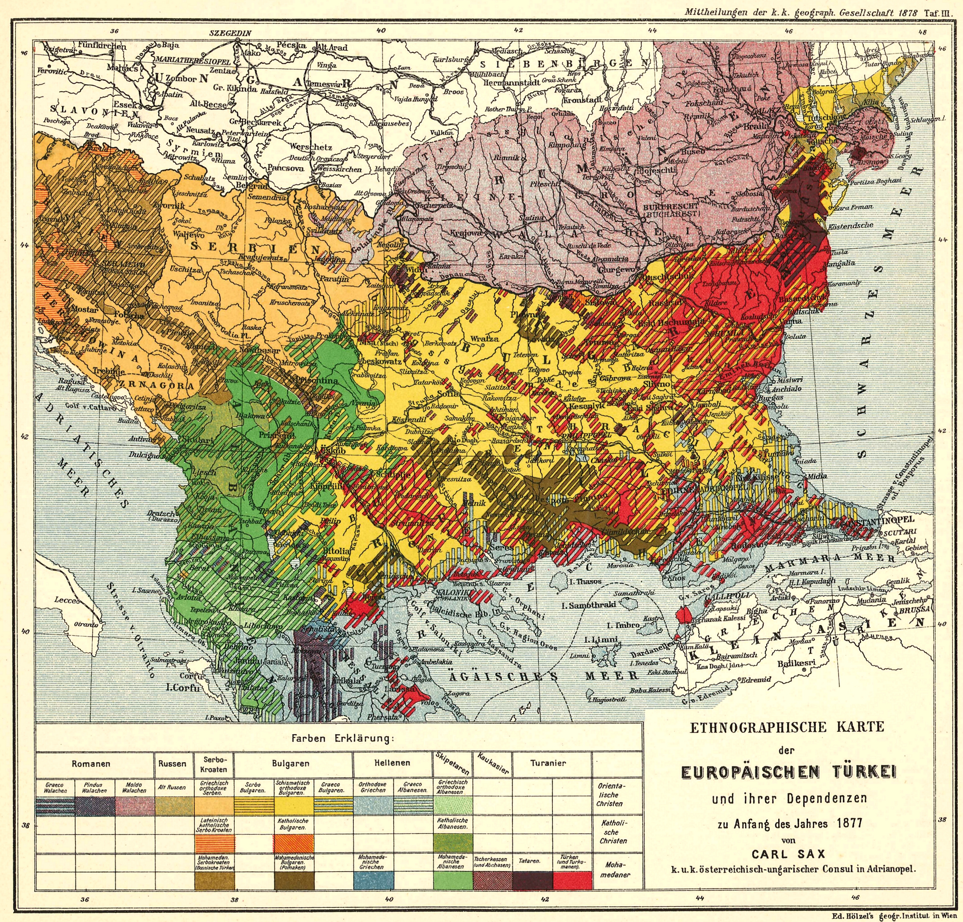
English: Ethnological Map of European Turkey and her Dependencies at the Time of the Beginning of the War of 1877, by Karl Sax, I. and R. Austro-Hungarian Consul at Adrianople. Published by the Imperial and Royal Geographical Society, Vienna 1878.
Български: Етнографска карта на Европейска Турция, автор: Карл Закс, 1877-1878 |
| Dátum | és 1878 között |
| Forrás | The Bulgarians in their historical, ethnographical and political frontiers, 1917 |
| Szerző | Carl Sax |
Licenc
|
Ez a mű közkincs abban az országban, ahol elkészítették, és minden olyan további államban, ahol a szerzői jogi védelmi idő a szerző élete plusz 70 év vagy kevesebb.
| |
| Megállapították, hogy ez a fájl mentes mindenféle szerzői jogi korlátozástól, beleértve az összes kapcsolódó és hozzátartozó jogot. | |
Fájltörténet
Kattints egy időpontra, hogy a fájl akkori állapotát láthasd.
| Dátum/idő | Bélyegkép | Felbontás | Feltöltő | Megjegyzés | |
|---|---|---|---|---|---|
| aktuális | 2008. május 28., 12:04 | | 3 100 × 2 968 (7,57 MB) | Alexandar.R.~commonswiki | {{Information |Description={{en|1=Ethnological Map of European Turkey and her Dependencies at the Time of the Beginning of the War of 1877, by Karl Sax, I. and R. Austro-Hungarian Consul at Adrianople. Publisched by the Imperial and Royal Geographical Soc |
Fájlhasználat
Az alábbi lap használja ezt a fájlt:
Globális fájlhasználat
A következő wikik használják ezt a fájlt:
- Használata itt: ba.wikipedia.org
- Használata itt: bg.wikipedia.org
- Használata itt: cv.wikipedia.org
- Használata itt: de.wikipedia.org
- Használata itt: en.wikipedia.org
- Demographic history of Macedonia
- Talk:Albanians in North Macedonia
- History of the Bulgarian language
- Bulgarian Turks
- Albanians in Serbia
- Wikipedia:Articles for deletion/Log/2010 April 29
- Wikipedia:Articles for deletion/Genocide of Ottoman Turks and Muslims
- Talk:Albanians/Archive 3
- Circassians in Romania
- User:Falcaorib/Balkans ethnic maps
- Használata itt: et.wikipedia.org
- Használata itt: it.wikipedia.org
- Használata itt: pnb.wikipedia.org
- Használata itt: ro.wikipedia.org
- Használata itt: ru.wikipedia.org
- Használata itt: sq.wikipedia.org
- Használata itt: sr.wikipedia.org
- Használata itt: tr.wikipedia.org
- Használata itt: ur.wikipedia.org